Recommended for beginner climbers! Enjoy a 360-degree panoramic view from the summit of Mt.Nagi!

There are several hiking trails on Mt.Nagi, but this one is for beginners. While a certain level of physical fitness and preparation is necessary to climb safely, Mt.Nagi is a relatively easy mountain to climb.

Written by
Okayama Prefecture is located in the Center of Western Japan and is known as the "Land of Sunshine" due to its warm climate and little rain throughout the year. It's conveniently located halfway between famous tourist destinations like Kyoto, Osaka, and Hiroshima! It's also the gateway to Shikoku via the Seto. Okayama is also known as the "Fruit Okayama," and the fruits that are sun-drenched in the warm climate of the Setouchi are of the highest quality in terms of sweetness, aroma, and flavor. You can enjoy seasonal fruits such as white peaches, Muscat grapes, and Pione grapes! Okayama is also home to world-class tourist spots, including Okayama Castle, Okayama Korakuen Garden, one of Japan's three most famous gardens, and Kurashiki Bikan Historical Quarter, which boasts history, culture, and art!
This service includes sponsored advertisements.
May is the perfect month for mountain climbing. We climbed Mt.Nagi while enjoying the fresh greenery of the Mori . We were blessed with good weather on the day of our climb, and were able to climb comfortably. During this interview, we climbed with two 80-year-old women. It had been about 10 years since one of them last climbed. We were worried about whether we could make it, but we spent a day climbing. On average, it takes about 5 hours to climb and descend.
Mt.Nagi

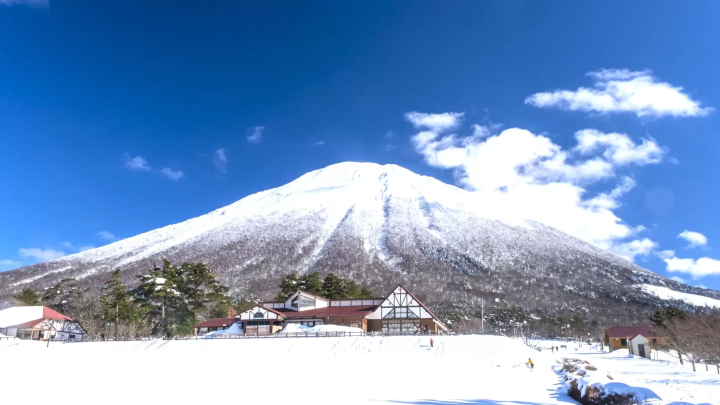
Mt.Nagi is a 1,255m high mountain that straddles Nagi Town(Okayama Prefecture) and Chizu Town(Tottori Prefecture), and is designated as part of the Mount Hyonosen- Mt.Nagi Quasi-National Park.
It is the second highest mountain in Okayama Prefecture after Ushiroyama. It is popular among climbers due to its beautiful scenery in all four seasons and its rich natural environment.
The view of Mt.Nagi from the Okayama Prefecture side is spectacular, and even if you don't climb the mountain, it's well worth the trip to see it.
Yamaguchi and climbing route

There are three hiking routes from Nagi Town: A, B, and C. Courses B and C are for beginners. Courses B and C have the same Yamaguchi, so you can climb from one and descend from the other. Even if you don't enjoy climbing up and down the same path, it's nice to be able to walk different courses on the way there and back.
The Yamaguchi. This is a slightly tough course, as you climb, then descend, and then climb back up again. There are also other courses from the Tottori Prefecture side, and courses that traverse the Mt.Nagi range of Takiyama and Hirotosen.
This time, we took Course B, which takes us up, and Course C, which takes us down. The course is about 8km long and takes about 3.5 to 4.5 hours. Some fast hikers can climb and descend in under 3 hours.
The Yamaguchi for courses B and C is located past Mt.Nagi Station, about a 5-minute drive up the mountain. Look for the stone pillar sign. Turn left at this sign and go up. There are three parking lots. Although it was a weekday, parking lot 3, which is closest to the Yamaguchi, was full. Nagisanroku Trekking Map (PDF)
Yamaguchi for courses B and C

It is located at the top of the mountain after climbing from the parking lot. From here, turn right and enter the mountain path. Please note that there are no toilets on the hiking trail. Toilets are located at the second parking lot.
[Climbing report] 9:00 Start of climbing
Climbing Course B, first half

A short climb from the Yamaguchi, you will come to a fork in the road, with trails B and C. If you go right here, you will be on trail B. Cross the bridge over the stream and climb along the stream. There are some steep sections, but most of the climb is gentle.
[Climbing Report] 9:11 Bridge
Course B: Oyataki Falls (side trip plan)

The Oyataki waterfall is located a little off the hiking trail. It has a large amount of water and is crystal clear. It is quite beautiful, especially with the fresh greenery. From the hiking trail, you can descend the stairs into the valley. It takes about 5 minutes one way. If you have the energy, it's worth a try.
[Climbing Report] 9:35 Oyataki Falls
Course B Kurotaki(side trip plan)

Kurotaki is also located off the hiking trail. It takes about 5 minutes one way. It looks like you can do some waterfall training. In the hot season, it seems like it would be nice to be splashed by the waterfall.
[Climbing report] 10:50 Kurotaki
Mountain climbing course Flowers

The mountain azalea was in bloom. There were also many other flowers that resembled violets. One of the purposes of this hike was to see the Enkianthus campanulata, but perhaps it was a little early in the season, so we weren't able to see any.
Climbing Course B, second half

As you approach the ridgeline, you can start to see the scenery at the foot of the mountain and in the distance.
[Record of mountain climbing]
11:50 8th Station
12:20 Reach the ridgeline. A course and Tosen course junction (Tottori side)
360 degree panorama from the summit!

You can enjoy a 360-degree view from the summit. An 80-year-old woman, who hadn't climbed the mountain in 10 years, managed to reach the top safely despite cramping in her legs! She was deeply moved by the magnificent view.
[Record of mountain climbing]
13:00 Arrive at the summit, take a break and have lunch
13:50 Depart from the summit
Panorama from the summit (Nagi Town, Seto Naikai side)

On a clear day, you can even see the mountains of Shikoku.
Panorama from the summit (towards the Nihon Sea)

Summit panorama (Daisen)

You can see Daisen in the distance, and a faint triangular point can be seen slightly left of the Chuo of the photo.
God and Buddha Points

Mt.Nagi was once a mountain of Shugendo (mountain asceticism). Characters believed to have been carved by Shugendo practitioners remain on some of the rocks. Please check the " Mount Nagi Foothills Trekking Map " for the locations of the Shinto and Buddhist shrines.
Downhill Course C Ogami Rock

You can see the town of Nagi from the top of Ogami Rock. This is also one of the gods and Buddha points. Behind Ogami Rock there is a hole just big enough for one person to fit through. It is said that if you pass through this hole, you will receive good fortune...
[Climbing report] 15:40 Ogami Rock
Hebibuchinotaki Falls (side trip)

Jabuchi Falls is located Oku the torii gate near the third parking lot. It takes about 5 minutes to get there. Legend has it that the mother of the legendary giant Sanbutaro lived there. If you still have energy after coming down from the mountain, it's worth a visit.
[Climbing report] 17:10 Descending the mountain and arriving at the Yamaguchi
We safely descended the mountain with two 80-year-olds. As it had been a while since we last climbed, we walked quite slowly and it took about eight hours, but I think most people can climb up and down in about half that time, about four hours (about five hours if you include breaks).
I think this mountain can be climbed even by beginners, but if you do climb it, be sure to prepare well and try to climb with someone who has experience.
Station at the foot of Mt.Nagi
 708-1307 591-1 Takamado, Nagi-cho, Katsuta-gun, Okayama Prefecture
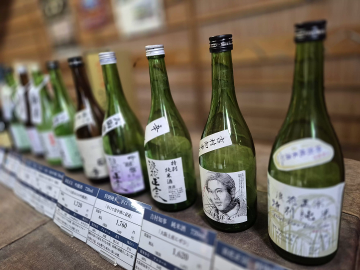
This two-story wooden mountain station is modeled after a traditional Japanese house in the Alps. The warm, relaxing atmosphere of a wooden structure includes a specialty product shop, a restaurant, and various experience and training facilities.
708-1307 591-1 Takamado, Nagi-cho, Katsuta-gun, Okayama Prefecture
This two-story wooden mountain station is modeled after a traditional Japanese house in the Alps. The warm, relaxing atmosphere of a wooden structure includes a specialty product shop, a restaurant, and various experience and training facilities.

Okayama Prefecture is located in the Center of Western Japan and is known as the "Land of Sunshine" due to its warm climate and little rain throughout the year. It's conveniently located halfway between famous tourist destinations like Kyoto, Osaka, and Hiroshima! It's also the gateway to Shikoku via the Seto. Okayama is also known as the "Fruit Okayama," and the fruits that are sun-drenched in the warm climate of the Setouchi are of the highest quality in terms of sweetness, aroma, and flavor. You can enjoy seasonal fruits such as white peaches, Muscat grapes, and Pione grapes! Okayama is also home to world-class tourist spots, including Okayama Castle, Okayama Korakuen Garden, one of Japan's three most famous gardens, and Kurashiki Bikan Historical Quarter, which boasts history, culture, and art!
The contents on this page may partially contain automatic translation.
Special Features
More


![[Mie] TOBA SEASIDE HOTEL Dining Guide | Popular Buffet & Seasonal Menu Introduction](https://resources.matcha-jp.com/resize/720x2000/2026/05/11-263832.webp)

![[80 minutes by train from Kyoto ] Experience the countryside in Fukuchiyama City , Kyoto Prefecture , a special place only locals know about](https://resources.matcha-jp.com/resize/720x2000/2025/12/19-253414.webp)