From Takenami Station to Ena Station - Introduction to the Nakasendo Trail - Part 1

Starting from Takenami Station on the JR Chuo Line, we will introduce you to the Nakasendo Route, which runs about 7km to Ena Station. Walk along the traditional mountain path and feel the thoughts and memories of Edo period residents and travelers from more than 300 years ago, which remain along the roadside. (Time required: approximately 3 and a half to 4 hours)

Written by
In order for the "local" to form a "scrum" and pursue the uniqueness of Ena together, Zivascrum Ena is working on sustainable town development. Opened an online shop “Aeru” where you can meet the charm of the region. We also operate AeruSTAY, which allows you to book accommodation and activity plans centered on outdoor leisure. We support activities that create new value and aim to create sustainable fans.
This service includes sponsored advertisements.
From Takenami Station on the JR Chuo Line, head towards Fukagaya Station
Nakasendo is one of the five main roads developed during the Edo period. The approximately 10km stretch that passes through Ena City still has many parts that still look the same, with a variety of stone structures and buildings remaining.

This time, we will be showing you the 7km route from Fukagaya Station, located 1.9km from JR Takenami Station, heading west on National Route 19 and turning right at the Takeori intersection, to Ena Station.
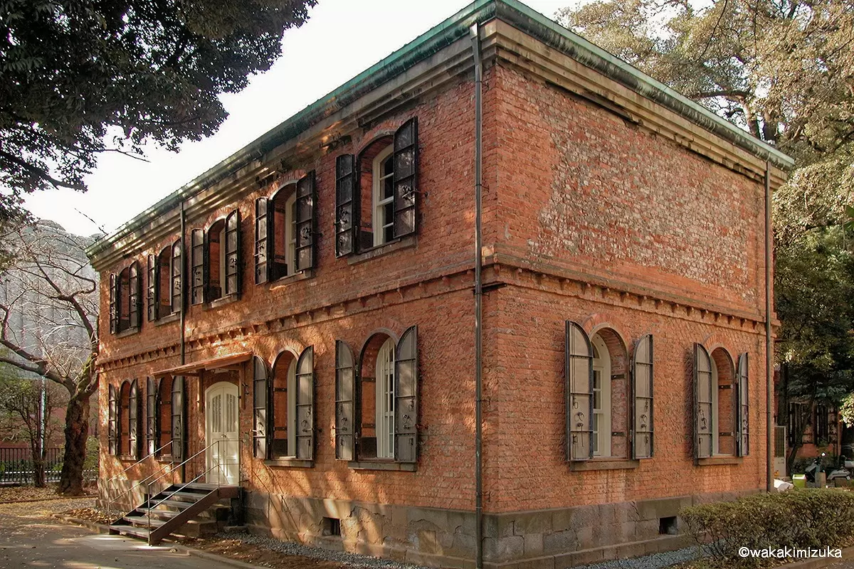
Fukagaya stand and Big bulletin board
Fukagaya honjin was a resting place used by people of high status among Nakasendo passers-by. According to the ``Odaimyo-sama Okoyasumi Oboetyo'' dated 1844, which is in the possession of the Kano family, which held the position headquarters, the number of times per month is about 5 on average, and 13 times per month. It is clear that he accepted a small holiday. Those who came were feudal lords and Edo officials.
If you go a little further from Fukagaya-honjin, you will find a big bulletin board.Kosatsu-ba is a bulletin board used to notify the common people of orders from the Edo Shogunate. At the bulletin board in Fujimura, there was a sign prohibiting Christianity and arson.
After passing the board, cross the small bridge that you will see on your right, and follow the narrow road (old Nakasendo) on the left.
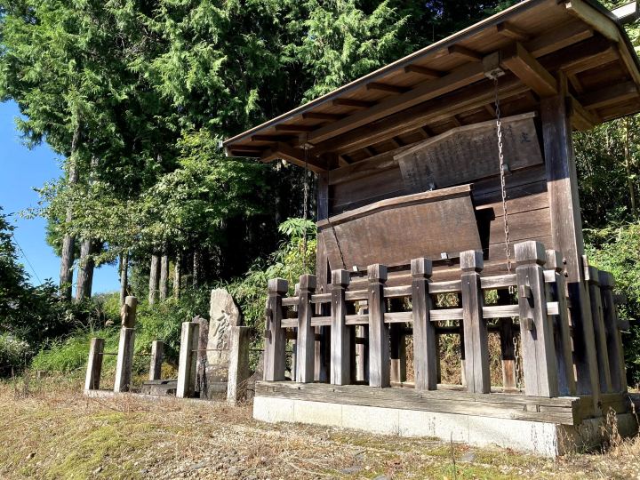
Sansha lanterns and Sakura Sogoro Daimyojin

At the end of the narrow road, you will see the Sansha Toro on your left. It was built in 1854 by a sake brewery owner named Kano Bunzaemon. The three shrines are Ise Shrine, Akiba Shrine, and Kotohira Shrine, and they pray for the safety of the village, a rich harvest, and caution against fire.

If you go to the left of the Sansha lantern, you will find Shinmei Shrine. There is a haiku monument by Matsuo Basho, a famous Japanese haiku poet. There are about 10 other haiku monuments lined up, but these were relocated from near the Fukagaya high note counter.

On the other side of the Sansha lantern, on the right side across the Nakasendo road, in the trees are enshrined Twenty-Two Nights, Inari Shrine, and Sakura Sogoro Daimyojin.
Long ago, when the people of this area were planning to use force against the feudal lord due to the hardships of their lives, Yoichi Tanaka, the village headman, went alone to Edo and appealed directly to the shogun. There is a story that Tanaka Yoichi's actions were enshrined in conjunction with Sakura Sogoro Daimyojin.
Benizaka Botan Rock and Ichirizuka
From the Sansha lantern, I walk along the path through the trees for a while. Along the way, you will pass several villages and a slope called Kurosukumozaka. After about 400 meters, you will start to see large rocks under your feet.

There is a part of the road called Benizaka where rocks are exposed. It is called ``Botan Rock'' because the surface of the rock is layered in thin layers and looks like a peony flower. In fact, it is a valuable rock as a specimen of "onion peeling" of granite.

Ichirizuka are distance markers built every 1 ri (approximately 4 km) along the old road, and are made by mounding earth to a size of 5 ken (approximately 9 meters) square and 1 jo (approximately 1.7 meters) high. Trees such as enoki and pine were planted on top.
Benisaka Ichirizuka is located 89 ri from Edo and 45 ri from Kyoto, and there are remains of it on both sides of the road.
Midarezaka and Midaregawa
Within about 1km from Ichirizuka, there are several points of interest, including the remains of a teahouse, the remains of a ticket office, and the intersection with the road leading to Iwamura Castle Town, which was known as the Tonosama Road.
Proceeding further towards the Oijuku side, where you cross a small river, you will come to a place called Midarezaka.

Midarezaka and Midarebashi are some of the most difficult spots between Oi-juku and Okute-juku. It got its name because the slope was so steep that it disrupted the procession of feudal lords, caused travelers to breathe irregularly, and even disrupted the hems of women's kimonos.
The river at the foot of the slope was called the ``turbulent river,'' and it is said that it was so rapid that even stones were disturbed.

The continuation, “From Takenami Station to Ena Station – Introduction to the Nakasendo Trail – Part 2” will be released at a later date!
In order for the "local" to form a "scrum" and pursue the uniqueness of Ena together, Zivascrum Ena is working on sustainable town development. Opened an online shop “Aeru” where you can meet the charm of the region. We also operate AeruSTAY, which allows you to book accommodation and activity plans centered on outdoor leisure. We support activities that create new value and aim to create sustainable fans.
The contents on this page may partially contain automatic translation.


Special Features
More


![[Introducing our English Program] Experience English-language activities at KidZania Tokyo!](https://resources.matcha-jp.com/resize/720x2000/2026/05/19-264204.webp)


![Enjoy popular spots in Okayama Prefecture with the great value digital travel ticket [Okayama Hare Tabi Passport]!](https://resources.matcha-jp.com/resize/720x2000/2025/04/28-232194.webp)